|
Kaw Reservations |
|
|
Prior to Missouri becoming a state in 1821, the
Kaws gave up
their land in western Missouri.
A treaty signed on September 25, 1818, by three principal
chiefs and eight warriors effected this land transaction.
|
|
In
return for their land, the U.S. government promised the Kaws
two thousand dollars worth of cloth, vermilion, guns,
ammunition, kettles, hoes, axes, knives, flints, awls, and
tobacco. These items were to be issued each September for an
indefinite period. A blacksmith was also promised to keep their
guns and implements in good repair. The bargain was sealed with
a gift of goods valued at $460 as proof of the government�s
good will and motives of benevolence.
|
|
Beginning in 1825, and continuing well
into the mid-1840�s, the federal government forcibly removed
nearly one hundred thousand Native Americans into "Indian
Territory," land which later became Oklahoma and Kansas.
Among the relocated tribes were the Shawnees, Delawares,
Wyandots, Kickapoos, Miamis, Sacs and Foxes, Ottawas, Peorias,
and Potawatomies. Such action required that the Kaws sign
treaties whereby vast acreage was ceded to the government in
return for annuities and promises of educational, agricultural,
and other forms of material assistance.
|
 |
|
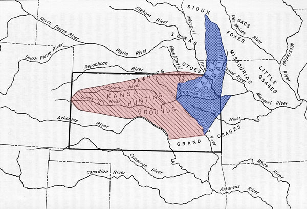
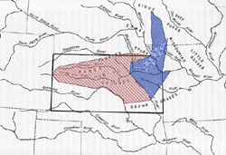
1825 The Kaws agreed to a reduction of
their twenty million acre domain, which comprised roughly the
northern half of future Kansas, to a two million acre
reservation. The eastern boundary of this reservation was just
west of future Topeka near the headwaters of the Saline and
Solomon Rivers. For this huge cession the Kaws were awarded a
$3,500 annuity for twenty years, a quantity of cattle, hogs, and
domestic fowl, a government blacksmith and agricultural
instructor, and schools to be funded from earlier Kaw land sales
in the Kansas City area.
|
 |
|
And, as a special concession
for Chief
White Plume�s vigorous support of this treaty, 640-acre plots
along the north side of the Kansas River just east of the new
reservation were granted in fee-simple to all twenty three
half-bloods of the Kaw tribe. The rest of the tribe received no
such benevolence thereby greatly encouraging factionalism.
|
 |
Article Eleven of the
1825 treaty said nothing about granting
Euro-Americans the right to move through Kaw land on the
overland trails. By 1825, the commercial value of the Santa Fe
Trail had increased substantially, and there lurked the danger
that the Kaws might obstruct this vital traffic.
|
|
In 1825, Sibley, Benjamin H. Reeves, and Thomas
Mathers,
members of the government survey team, met several Kaw Chiefs
at the Sora Creek crossing of the Santa Fe Trail, just south of
present-day McPherson. Here the Kaw chiefs and headmen agreed
to allow the survey party to continue its work unmolested for
$800 in cash or merchandise paid directly to tribal leaders. The
trail was to be "forever free for the use of the citizens
of the United States and of the Mexican Republic."
|
Artist Charles Goslin |
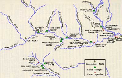 |
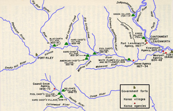
The old
Kaw village near the mouth of the Big Blue River
was partially abandoned about 1830; during that year, the tribe
established three villages lower down on the Kansas River. The
village of American Chief was on the creek of the same name (now
Mission Creek) about two miles south of the Kansas River.
|
This
band, of about one hundred had twenty good sized lodges, in
which they lived until the Kaws removed to Council Grove in
1848. About a mile from this village was Hard Chief�s village
situated on a high bluff on the south bank of the Kansas River.
This village had about 500 people and 85 lodges. It was about 1
and 1/2 miles west of the present-day Kansas History
Center. The third and largest village, that of Fool Chief, was on the
north bank of the Kansas River, on the western edge of present
north Topeka.
|
|
The treaty language stipulated that a government agent,
farmer, and blacksmith were to reside at or near the principal
villages. Yet in the two decades after the treaty was ratified,
this provision was loosely enforced or completely ignored. Never
did the agent (or subagent) live closer than twenty miles from
the main tribal villages. In some instances the distance was
between fifty and seventy-five miles. Moreover, a chronic
turnover in official personnel assigned to the Kaws, along
with continual reorganization of the Department of Indian
Affairs at the agency level, resulted in a confusing array of
agents, subagents, assistant agents, special agents,
commissioners, blacksmiths, and farmers. Often there was no one
to look after the government�s obligations to the Kaws.
|
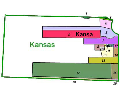
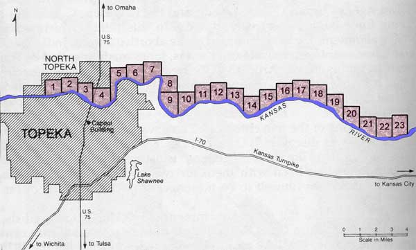
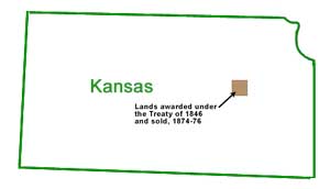
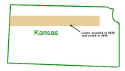
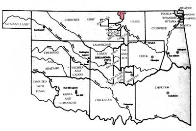
| 1846
Reservations in Kansas |
1.Otoe
& Missouri
2. Iowa
3. Sauk & Fox of Missouri
4. Kickapoo
5. Delaware & Wyandot
6. Kansa
7. Shawnee
8. Sauk & Fox of Mississippi
9. Chippewa
10. Ottawa |
11. Peoria & Kaskaskie
12. Wea & Piasnkashaw
13. Pottawatomie
14. Miami
15. New York Indians
16. Cherokee Neutral Lands
17. Osage
18. Cherokee Strip
19. Quapaw Strip
W. Lands in common use by 8 & 9 |
|
|
|
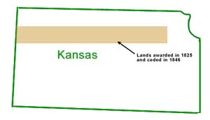
The next major land cession treaty was signed by Kaw chiefs
in 1846. The Kaw sold their two million-acre reservation
established in 1825 to the U.S. government for just over ten
cents an acre. This money was to be dispensed to the Kaw tribe
over a thirty-year-period at a rate of fifteen thousand dollars
a year. The Kaw were to be relocated to a twenty-mile-square
reserve located in preset southern Morris County and northern
Lyon and Chase counties.
|
 |
In the spring of 1848 the 1600 remaining Kaws moved,
establishing three new villages in the area, which were located
in the Neosho Valley approximately three, seven, and ten miles
downstream from Council Grove.
|
|
|
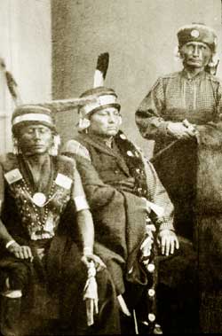
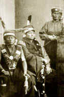
Each
village was led by two generations of chiefs during the 25 years
the Kaw lived on the Neosho Valley Reservation. Initially, the
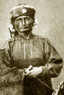
chief of the village closest to Council Grove was Peg-Gah-Hosh-She.
He was succeeded by Wah-Ti-An-Gah. Ish-Tah-Lesh-Yeh was chief of
the middle village, being succeeded by Ka-He-Ga-Wa-Ti-An-Gah.
And the first chief of the village ten miles from Council Grove
was Ka-He-Ga-Wa-Che-Cha. His successor was Al-Le-Ga-Wa-Ho, who
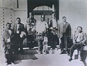
in 1867 became the head chief of the entire Kaw Tribe.
|
 |
|
Traders and government agents soon followed the tribe to the
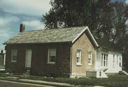
new location. Seth M. Hays, the first permanent white settler at
Council Grove, established his home and trading post in 1847
just west of the Neosho River on the north side of the Santa Fe
Trail.
|
 |
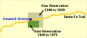 |
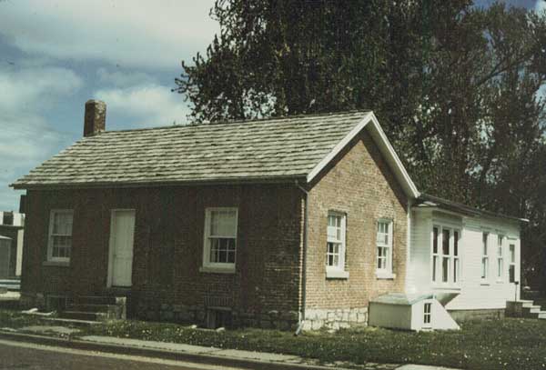
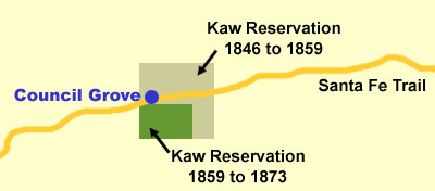
When Kansas became a territory in 1854 hundreds of land-hungry whites
already had settled illegally on the Kaw Reservation. An 1859 treaty
diminished the reservation to an area nine by fourteen miles.
The Kaw agency was moved from Council Grove to a point about
four miles southeast of the town.
|
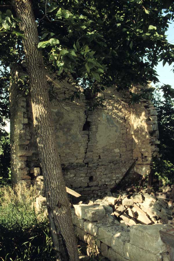
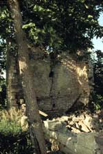 |
There, a new agency building
and stone huts for the Kaw were constructed; the remnants of
which can still be seen today. Educational efforts of the new
agency were placed in the hands of the Quakers, but these
efforts, like those of the Methodists, met with little success.
|
|
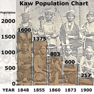
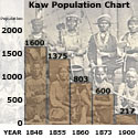
The living conditions of the Kaw on the Neosho Valley
Reservation were not conducive to good health and happiness. The
tribe was frequently ravaged by contagious diseases, especially
smallpox, and the population declined from 1600 in 1848 to about
800 in 1860 to 600 in 1873. Meanwhile, the Kaw were under
constant pressure from land speculators and squatters.
|
 |
|
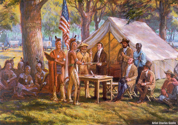
In 1872 the
secretary of the interior of the U.S. government,
Colombus Delano, came to Council Grove to "negotiate"
a final treaty which would remove the Kaw from Kansas once and
for all.
|
 |
Al-Le-Ga-Wa-Ho made an impassioned plea to Delano with
the following words: "Great Father, you whites treat us
Kansa like a flock of turkeys, you chase us to one stream, then
you chase us to another stream, soon you will chase us over the
mountains and into the ocean and we will have no place to live.
We do not want to leave the Neosho Valley."
|
|
The Kaw chief�s appeal was ignored, and the 600 remaining
Kaw were removed to a reservation in Oklahoma, then called
"Indian Territory." Their numbers in Oklahoma
continued a rapid decline; with only 217 members listed on the
Tribal rolls in 1900
|
 |
|