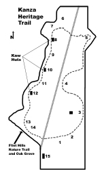
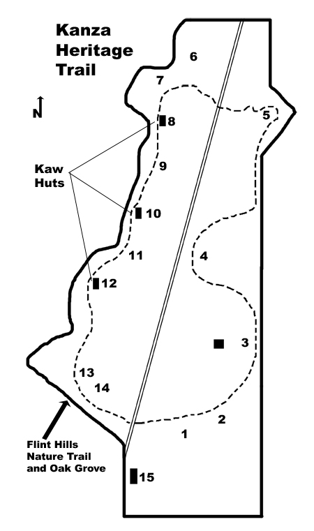
 |
| Kanza
Heritage Trail
|
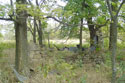
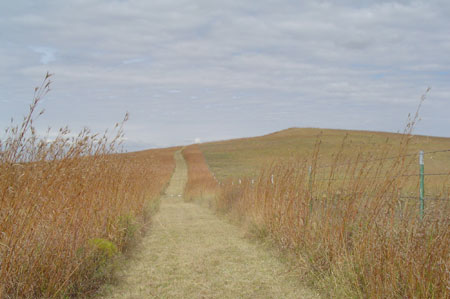
The two-mile long Kanza
Heritage Trail loops through the beautiful and historic
158-acre Allegawaho Memorial Heritage Park owned and
managed by the Kaw Nation, a self-governing tribe of
2,900 members. Currently based in north central
Oklahoma. The Kaw Nation is actively working to regain
its cultural heritage, which was nearly lost when the
Tribe was forcibly removed from Kansas in 1873. By
walking this Trail, you will engage a wonderful
landscape steeped in natural beauty and the rich
cultural history of the Kanza people who once lived here
Note: Click on map or pictures for a larger image.
|
|
 |
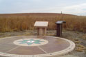
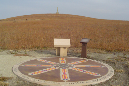
1.
Pause Point #1
A bronze plaque of the Kaw Tribal Seal is located at
the center this pause point. Cast stone centerpieces
contain patterns of ribbon weaving for which the Kanza
are famous. Images are engraved in cast stone sections
with relief areas filled with color epoxy. A prayer that
is written in the outer rim of the circle reads: "Wakanda
- Bless all who walk here. May we know and respect all
your creation and what you have taught our people.
Wiblaha."
|
2.
Proposed Visitor/Interpretive Center
In time to come a 4,100 s.f. circular building will be
built at this location to house display areas, exhibits,
auditorium, gift shop, offices, kitchen and restrooms.
Future plans include park staff to assist visitors,
distribute information and facilitate tours.
|
 |
|
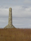
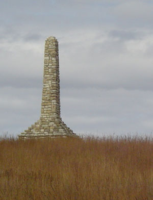
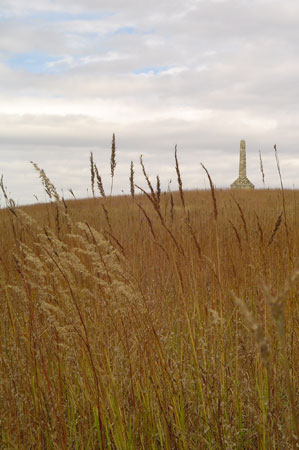
3.
Monument to the Unknown
Kanza Warrior
The limestone tower you see near the beginning of the
trail was erected by local citizens in 1925. The
thirty-five-foot high spire was built as a tribute to
the memory of the Kanzas' presence in the area. This
commemorative act was prompted by the discovery of a
warrior's remains exposed by cut bank erosion in a
nearby streambed. The warrior and his burial
paraphernalia were entombed in the base of the monument
in August 1925 during an elaborate dedication ceremony
attended by several members of the Kaw tribe. The Kaw
Nation asks that you honor the deceased by maintaining a
respectful distance from the monument.
|
 |
4. Little John Creek Valley
Overlook (2,929 feet)
The timber stretching north-south in the valley below
marks the course of the Little John Creek. This valley
offered the Kanzas abundant timber, water, grass, and
rich soil. During the Kanza occupation of the Council
Grove Reservation from 1848 to 1873, they lived nearby
in a village. The first village chief, Peg Ah Ho Shee,
died in the late l860s. He was succeeded by ChiefWah Ti
An Gah.
|
|
|
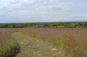
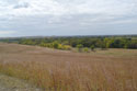
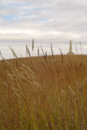
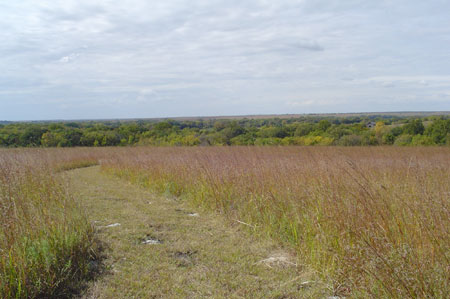
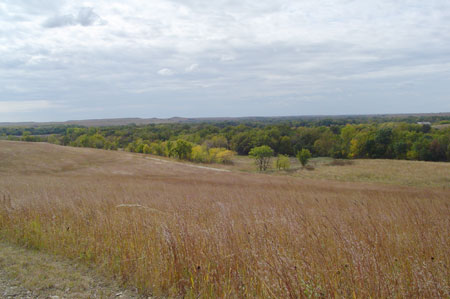
5.
Promontory
(4,646 feet)
This highest point in the park affords a wonderful view
of the surrounding Flint Hills landscape. You have
entered one of the last vestiges of a vast tallgrass
prairie that once covered much of the Midwest. As the
white frontier expanded west thousands of "sodbuster"
plows tilled the prairie grasses under. But here on the
western edge of that vanished tallgrass expanse, prairie
plants still flourish in regions of thin-soiled uplands
known as the "Flint Hills." Note: Visitors with
health restrictions may want to skip the steep climb to
the point.
|
 |
6.
Prairie Restoration
(5,464 feet)
The Kaw Nation has converted thirty-five acres of
bottomland into tallgrass prairie. Native tallgrasses
such as big bluestem, switch grass, Indian grass, and
indigenous wildflowers now flourish where farm crops
once grew.
|
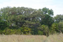
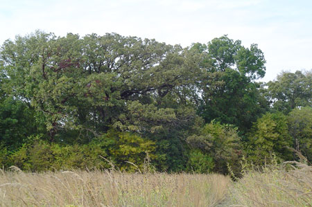
7.
Grandfather Oak
(5,976 feet)
This fabulous bur oak easily pre-dates the Kanza
occupation of this valley. The Kanza word for bur oaks
is tta ska hu. Like the Kanzas, Bur Oaks are
native to this area. The Bur Oak is a long-lived
species; some like this one have survived for more than
two hundred years. The resiliency and strength of bur
oaks are qualities reflective of the tenacity and
purpose of the Kaw Nation in reclaiming a portion of the
tribe's former homeland in Kansas.
|
 |
|
|
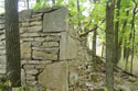
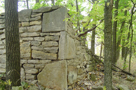
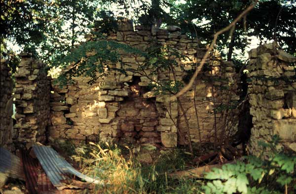
8.
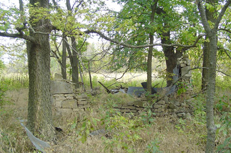
Wah Sko Mi A's Hut (6,494 feet)
These stone ruins are the remains of one of 138 huts the U. S.
government built as dwellings for the Kanzas in 1862. The stones were
quarried from the side of the hill you just descended. The mortar is
made up, in part, of the gravel from the streambed of Little John Creek.
The measurements of the three huts in this park are 16 by 20 feet. The
Kanzas chose not to live in these structures, using them as stables for
their horses instead.
|
|
|
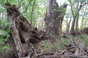
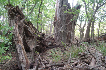
9.
Fallen
Cottonwood (7,018 feet)
Today most of this immense cottonwood sprawls across the
ground, nurturing the variegated fungi sprouting from
its lifeless hulk. The cottonwood held spiritual
significance to the Plains Indians. The slightest breeze
will make the cottonwood leaves shake and clatter like
raindrops. The seemingly constant rustling ofleaves
reminded them of the wind, which the Indians believed
served as the path and voices of Higher Powers. The
Kanzas are strongly associated with wind, as the
original version of the tribal name, aca, has
been translated to mean People of the South Wind.
|
10. Kick A Poo's Hut (7,018 feet)
Why did the Kanzas reject these huts? They preferred
round dwellings, such as their tipis and bark-and-mat lodges, in which
they had lived comfortably for generations. The huts were designed as
single-family dwellings similar to that of the Euro Americans whereas
the Kanza had lived communally for centuries with an entire family
inhabiting one dwelling. In 1862 the government was assigning 40-acre
allotments to each member of the tribe. The whites hoped that the Kanzas
would spread out over the reservation, farming the land adjoining their
new huts in the European way. The Kanzas preferred to remain in their
three villages, where they could continue to practice their ancient
communal traditions.
|
 |
11.
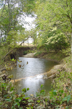
Little John Creek (8,007 feet)
The source of this creek is just a few miles north.
Little John Creek is an intermittent stream, with water
running through it in wet seasons and after significant
rainfall. But even in dry times, you can find a few
pools. The Little John joins the Big John Creek less
than a mile southwest of this point. Big John Creek
shortly flows into the Neosho River, which joins the
Arkansas River in Oklahoma. People have mined the Little
John Creek in the past for gravel; some of the mounds
you have seen along the trail are the residues of these
excavations.
|

|
|
 |
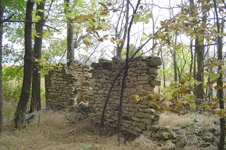
12. Ke La Lah Heo's Hut (8,242
feet)
The huts had one room with a fireplace. After the Kanzas
were forced to leave, the settlers lived in these
structures. Later, after they had built their homes, the
white people used the huts as outbuildings for their
farms. The panels of corrugated metal in the vicinity of
the huts are relics of the Euro-American period of
occupation.
|
|
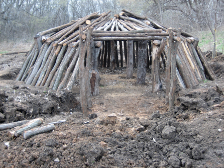
13. Kanza Earth Lodge
This 25' diameter replica of a Kanza earth lodge
gives park visitors an opportunity to learn about the
traditional Kanza life style. Visitors can experience
'first hand' what it was like to live as a Kanza in
homes of this type in the Council Grove area. The Kanza
used at least two different types of homes. When
traveling to hunt buffalo the tipi was typical. The more
"permanent" home was a bark or earth lodge. The earth
lodge structure, funded through the Atchison County
Historical Society Challenge Cost Share Grant and the
Kaw Nation, was built over a two-year span of time by
volunteers and Kaw Nation staff.
|

|
 |
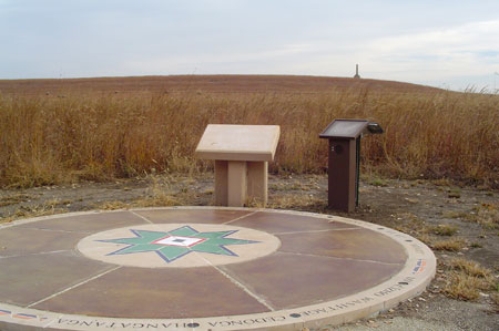
14. Pause Point #2
At the center of this pause point is a cast stone
pattern taken from a beaded Kanza belt. Sixteen Kanza
clan camp names are engraved in the outer rim of the
circle. Interspersed with the clan names, patterns taken
from the beaded belt work appear on the north, east,
south, and west sections of the rim. All images were
engraved in cast stone sections with relief areas filled
with color epoxy.
|
|
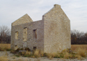
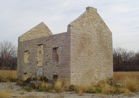
15. End of the Trail
(10,380 feet)
As you leave the park, take a minute to visit the
stabilized ruins of the "Agency Building" and speculate
on the events which may have occurred there as the
Kanzas interacted with the government officials. It was
at the Kaw Agency in June 1872 that the great Kanza
chief Allegawaho made his eloquent protest against his
people being forced once again to move from their
beloved homeland.
|
|
|
Today
you have walked in the path of the Kanzas who lived
here, the farmers who plowed the fields, and the deer
who created the woodland track. Research will continue
to inform and shape our interpretation. We hope you will
return to experience the park as it evolves.
|
|
|
|
|
|
|
